Chapter 5: Seattle to Goat Rocks Wilderness
Updated July 2022
See also - Mountain
Goats Drank my Pee
Bus schedules change often so it's useless to post times that will inevitably change. Here are the pertinent bus systems; see links page for current timetables.
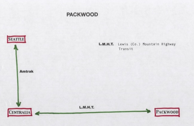
This transit sequence gives you access to Lake Packwood, Goat Rocks Wilderness, which contains the highest section of the PCT in Washington, and Snowgrass Flat.
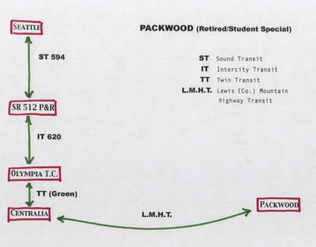
Important notes on reaching this area: The Seattle-to-Centralia transit leg of the route is simple. You have two options: either take Amtrak the whole way (as of Spring 2022, one-way fare runs $25); or take the public transit option (see Student/Senior/El Cheapo graphic; it’s a bit more complicated and takes longer, of course, but only costs about $6).
The Centralia-to-Packwood leg of the transit route has acquired complications of its own, thanks to COVID-19. The rural eastern half of Lewis County (through which your bus passes) has been hit really hard by COVID, so much so that the bus route shut down completely for the first two months of 2022.
They resumed service in March, but with major restrictions: Lewis (County) Mountain Highway Transit (LMHT) will be running, for the present, Monday, Wednesday, and Friday only (instead of their usual Monday through Friday). Reservations will be required, along with submitting proof of fully vaccinated COVID status (status must be communicated to Office Staff prior to reservations being made).
Sure—it sounds like a lot to ask, but for the safety of their riders, drivers, as well as their greater community, it was the only way they could keep the route in operation. Consider this: the backcountry destinations you’d be heading to in Goat Rocks usually don’t even melt out until late July/early August anyway (this area is, for me, a premier early Autumn trip). By then, things may improve, COVID-wise, allowing relaxation of these policies and restrictions. We can only hope.
Highwayshopper.com posts the LMHT schedule (current as of March 2022). LMHT can also be reached by phone at (360) 496-5404. This info is also posted on our Transit Links page.
from transit to trailhead: Leave L.E.W.I.S. Mountain Highway Transit at its route end at the Senior Center at the south end of Packwood. Walk to the north end of town (it’s about a third of a mile, I think), turn uphill at the (currently unoccupied) Ranger Station. It’s about 9 miles to the lake; you may consider spending the night at Hotel Packwood (it’s old and funky, but quaint and lovely—and you can get a room for under $40), and starting fresh in the morning.
An alternate approach to Goat Rocks Wilderness can be made from its south side, by leaving the bus at Forest Service Road 21, and walking 16 miles to reach the trailhead at Berry Patch, heading north. (Camp sites can be found along the road, in a pinch.)
from trailhead onward (via Lake Packwood): Truth to tell, I’ve never walked the actual trail to the lake: there is a service road for the electric company that keeps the tiny dam at the lake running, that straight-shots to the lake (so it’s shorter than the actual trail, without all the switchbacks and up-and-down of the trail). Look on your map—it’s right there! The service road offers some great views of the valley, and of Mount Rainier. Plus, thanks to this shortcut, you might actually reach the lake before dark. Besides, all the real treasures are above the lake, anyway.
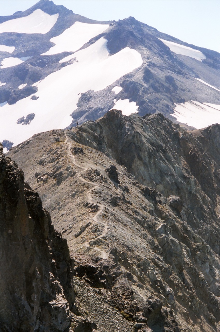
As you pass the lake, you enter Goat Rocks Wilderness, and begin passing many cedars 6 to 10 feet in diameter. You pass through a long grove of vine maple and alder that is spectacular in autumn, then start gaining elevation. Last water is just below the Packwood Saddle. Eventually, you reach the ridge and soon join the PCT. Weather permitting, you may cross the Knife Edge (which, if the weather’s iffy, can look and feel as scary as it sounds) and reach the highest point on the PCT in the state of Washington (7600 feet). Sometimes, if conditions aren’t safe, you have to turn around and back out. No shame in that.
from trailhead onward (via Berry Patch trailhead): It’s an afternoon’s trip to Snowgrass Flat, which offers massive views to the south, of Mt. Adams, St. Helens, and a distant Hood. Beyond that is steepness, lots of it, and ever more amazing vistas. You’re walking below the crumbling rim of an ancient supervolcano. You can see Goat Lake off to your left (a side trip is possible). If you continue, you’ll eventually reach that highest point of the PCT mentioned above. You can make a loop of it, or leave your pack at Snowgrass and do the rest as a day trip. There’s a magical spot where you can see the three mountains to the south, pivot your feet, and see Rainier to the north. There are other loops trips possible from Snowgrass, too.
The snow doesn’t melt off in a normal year until late August or even September, which is about two weeks before the snow starts back up again. Be careful up there, and don’t be afraid to back out if it’s beyond your comfort level (a couple times, I’ve turned around. But then I’ve always been a wimp. And a live one.).
See also - Mountain Goats Drank my Pee
They resumed service in March, but with major restrictions: Lewis (County) Mountain Highway Transit (LMHT) will be running, for the present, Monday, Wednesday, and Friday only (instead of their usual Monday through Friday). Reservations will be required, along with submitting proof of fully vaccinated COVID status (status must be communicated to Office Staff prior to reservations being made).