 Chapter 1: Seattle to Olympic National Park (North Side)
Updated July 2022
See also: Food, Sex & Death on the Dungeness
See also: Getting Loster
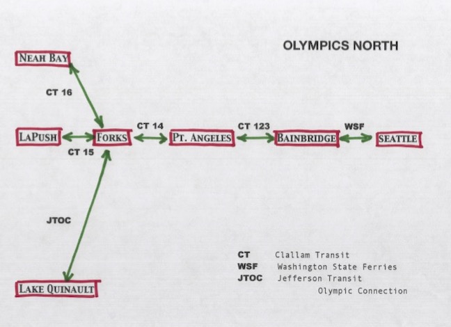
Bus schedules change often so it's useless to post times that will inevitably change. Here are the pertinent bus systems; see links page for current timetables.
This sequence of buses gives you access to ONP’s north side, as well as their famed wild coastal beaches. Your options here include:
- A. Dungeness River
- B. Hurricane Ridge
- C. Elwha River
- D. Olympic Hot Springs
- E. Sol Duc River
- F. Coastal Beaches North
- G. Coastal Beaches South
A - Dungeness River
From bus to trailhead: Leave CT 123 at the Sequim stop (and it’s pronounced ‘squim’). Your scheduled arrival time (on a weekday morning run from Seattle) is 11:40 AM. Tell your driver you’re trying to catch CT 52; if your bus is running late, the driver can radio the dispatcher and hold the 52 for you. If you’re on time stay right at that stop—don’t run across the street for coffee: CT 52 leaves there at 11:45 (and the next one’s in about 5 hours). You’ll be heading briefly back in the direction you came from. Tell the driver you want off at Sequim Bay State Park (and find out exactly where this same bus stops heading back toward Sequim, for your return trip—this detail is important!).
Once you leave the bus at Sequim Bay State Park, take the underpass to reach the other side of the road (Seriously—it’s a state highway, cars go really fast, and you’ll likely be burdened with a heavy backpack). From here, it’s 8.5 miles to the first trailhead. Find Louella Road, head uphill to Palo Alto Road. Go left. Follow signs to Dungeness Forks Campground.
From trailhead onward: You don’t have to make a reservation with Olympic National Park (ONP) unless you plan on entering the Park—and you’ve got plenty of options without doing so. Check your map. You can stay on paved or gravel access roads for several miles (and make better time), or you can remain on trails. These trails and roads interweave. You can continue to Marmot Pass without entering the Park; cross the pass and drop down Big Quilcene Creek to exit at Quilcene (see Chapter 3 for more info).
B - Hurricane Ridge
News Flash! Beginning 1 June 2022, CT will be running a bus shuttle service from downtown Port Angeles (Gateway Transit Center) to Hurricane Ridge. The shuttles will run 3 times daily, 7 days a week, including holidays. They will run from 1 June until the end of September. The shuttle costs $1 each way, though trips this June will be free.
The fine print: Proof of paid Park admission must be presented to [bus] operator PRIOR TO BOARDING BUS. See info on CT site, or visit www.recreation.gov/sitepass/74290 . Arrange all of this before your trip. You’ll be entering ONP, so all the same requirements apply.
from trailhead onward: Once you get there, you’re in high country, amid peaks and bare rock, and with impressive views. And every direction you go will necessarily be downhill. Trail connections exist for all the drainages on the east side of the Olympics. So you could venture downslope on any of several trails and exit the Park there (to buses you’ve already researched…). Or you could take the shuttle back to P.A. and home.
This is game-changer, folks! Until now, one had to walk 17 very steep miles up a winding road, or possibly play hitchhiking/strangers-with-candy-roulette. No more! I’m, like, new-girlfriend-giddy! [Both I and Our Editor think this is weird and kind of sad.]
C - Elwha River
from bus to trailhead: Leave CT 14 at Elwha River Road. Walk 4 miles along easy paved road, then head up 5 steep miles along a coarse gravel road to Whiskey Ridge trailhead.
Alternatively, you could take the Hurricane Ridge shuttle, then drop back down to the Elwha, saving yourself some arduous uphill road walking.
from trailhead onward: Stroll the wide Elwha River Valley. You’ll only gain 1000 feet of elevation in the first 20 miles, so you’re likely only barely aware you’re going uphill. Big trees, interspersed with open meadows. The trail seldom gets near the river, but it crosses countless streams. so there’s plenty of nearby water. Go in a day or two, camp, make side-trips, come back out. If you continue on, you can cross the Low Divide and exit via the North Fork Quinault (that’s a long-ass trip, with three river fords, but you’ll never forget it, and it looks good on your trail resume...). (I just made that up—not that it looks good, but that there’s such a thing as a ‘trail resume.’ But if there really was, this trip’d be on it!)
D: Olympic Hot Springs/Appleton Pass:
from bus to trailhead: Leave CT 14 at Elwha River Road. Head up road. Follow Hot Springs Road; you’ll gain 2000 feet in 8.5 miles to reach the trailhead.
from trailhead onward: A few words on Olympic Hot Springs: they consist of a dozen-ish shallow pools, each about as deep as your bathtub, and with muddy or silty bottoms. They’re spread out over a couple acres. They’re murky and sulfurous. They’re isolated from each other, in dense third-growth forest. They’re only about two miles from the trailhead, along the crumbling remnants of an old paved road, so they’re real easy to get to. The latest bacteria count for the pools is usually posted at the trailhead info kiosk. They attract a bad crowd; each pool is isolated, as I said, and women have been raped there. Bear all that in mind.
But the real treat is access to Appleton Pass, stepping-off point for a bunch of different places. Check your map.
E: Sol Duc River
from bus to trailhead: Leave CT 14 at Sol Duc (pronounced as in, ‘the only water bird’) River Road. Head in along largely flat, well-paved road. 14 miles.
from trailhead onward: There’s a long, gentle river trail that takes you toward the High Divide, leading you eventually to the very top of the Sol Duc drainage (at the end of which is a stepping-off point for an off-trail traverse of the Bailey Range—or you can go to that point and just look. Like I did.) From near that same point, you can look south for a really close view of the north side of Mount Olympus.
Two other trails take you away from the river early on, leading you toward connections with the Bogachiel (call it the ‘Bogie’— with a long ‘O’, like the actor’—people will think you’re a local) and the Hoh.
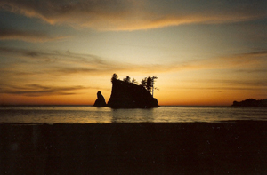
F: ONP Coastal Beaches North (from Shi Shi (‘shy-shy’) southward):
from bus to trailhead (north end—Shi Shi): Leave CT 14 at Sappho (tell the driver that you’re trying to get to Neah Bay—they’ll make sure you make your connection to CT 16 to Neah Bay).
Reaching Neah Bay, follow the Cape Flattery Road out of the village. You may be able to catch the Makah Tribal Transit bus while you’re still in town—it’ll save you 2 miles of walking. Head south on Hobuck Road across the Waatch River. Get an actual map— you may or may not be able to get coverage on your phone. You really are at the edge of the world out here. It’s about 8 miles without the Makah bus ride, or 6 miles with.
from trailhead onward: You’ll walk a meandering path from the parking lot, and will eventually meet a monster of a boot- swallowing stretch of mudholes that continues for a mile. Don’t try this in failing light. Reaching Shi Shi Beach, head south. You’ll have 2.3 miles of lovely sandy beach, then it gets all rugged and rocky, with rope-assist climbs. You’ll be up off the beach, and back down, several times. Watch your feet and handholds. Your map will tell you where you should and shouldn’t be during high tides— heed these warnings. You’ll want to have your camera or phone in your hand at all times, but don’t. Rocks are slippery, wet or not. I’m not trying to scare you. Oh, wait—yes, I am! From the north, you can either come back out the same way, or at the far south end, at Rialto Beach, 33 miles away. (You could hike up away from the beach to Lake Ozette, but there’s no bus there, and the road from there to the highway is 30-plus miles long.)
Here’s my unsolicited opinion: If you do this trip north-to-south, you’ll be fighting the tides the whole way. As in, set yourself up to cross a dicey spot that’s marked on your map as ‘Cross Only at Low Tide.’ Cross that one, and you find another one a couple hours later marked on your map with the same notation—but the tide has since come in. So you wait 6 hours or so for the tide to turn again... Particularly on the north end of this route, there’s a whole string of spots like that. You end up spending way too much of your time waiting for the tide to turn. Going south-to-north, it just flows better; I don’t know why. It just does. Thus endeth the unsolicited opinion.
from bus to trailhead (from Rialto Beach northward): Continue with CT 14 all the way to Forks; catch CT 15 there, heading toward La Push. Tell driver you want off at Three Rivers Resort (the three rivers are the Sol Duc, the Calawah, and the Bogachiel— which join just below there to form the Quileute for the last few miles of its existence). Walk 5 miles down the Mora Road to road’s end at Rialto Beach.
from trailhead onward: This end of the route is a lot more forgiving than its northern end—there’ll be a lot more sandy beach, and the few rope-assists that there are can be avoided even on a medium tide. There are several rocky sections. Observe the tide chart and follow its advice. Take pictures every 5 minutes, but watch where you place your feet. This might be a good place for walking poles, if you use them (I’ve never walked this beach without falling at least once). There will be giant logs perched on the beach, but the moment you put your weight on one, you find that it had been perfectly balanced on some unseen fulcrum and is now pivoting wildly and trying to throw you somewhere you really don’t want to be. Be prepared for stuff like that. Pay attention. Again, you can stay for a night or two, then turn and leave at Rialto, or from the other end at Shi Shi, 33 miles away.
G: ONP Coastal Beaches South (from Third Beach southward):
from bus to trailhead: Catch CT 15 at Forks Transit Center. It goes to LaPush. Tell the driver you’d like to leave at the Third Beach trailhead. Mileage to trailhead: maybe 100 feet. You’ll pass through lovely big trees for maybe an hour before you hit the beach. You’ve a lot of camping options over the next 10 miles. There are a lot of overland stretches; note: where the map says ‘ladder,’ it translates as, ‘ladder, ladder, ladder, rope, rope, then rope, rope, ladder, ladder...’ down the other side back to the beach. But with each of those ladder-ordeals, the crowds of people decrease.
Pay attention to your tide chart—sometimes it decides how far you can go at a given time. For crossing Goodman Creek, take a pair of flip-flops: there are actually three crossings, with a fair amount of mud in between (and Goodman is tidal, so high tide may affect, or even stop, your crossing). At Mosquito Creek, there are some nice tide pools just south of the crossing that can be explored as a day trip during low tide. But the thru-route south of the creek spends 5 miles well off the beach—you can hear the surf, but not see it, not a glimpse—slogging through some serious mud holes. As in, really not worth it. I’d recommend exiting back at Third Beach, unless you’re really fond of mud (and the 11.5 mile walk uphill from Oil City to the highway).
N.B. : Buses, er, well... one bus... continues south from Forks Transit Center: Jefferson Transit’s Olympic Connection. You’ll note that JTOC, on weekday afternoons, is scheduled to leave Forks 10 minutes before your CT 14 arrives there. Which might put you in a world of annoyance if you plan on heading farther south. I checked with Clallam Transit, and their customer service department told me that if want to connect with that next bus, to tell your CT 14 driver upon boarding in Port Angeles what you’re trying to do, and that driver will radio their dispatcher and hold the JTOC bus for you (and CT is looking into adjusting their schedule on their next schedule change-up to correct that gap). Those trail options south of Forks I will detail in Chapter 2, as there is some time advantage to be gained by approaching them from the south. You’ll reach them earlier in the day (although you do have to leave Seattle earlier). Your call.