 Chapter 2: Olympic National Park (West Side, via southern transit approach):
Updated July 2022
See also: A
Trail Less Traveled
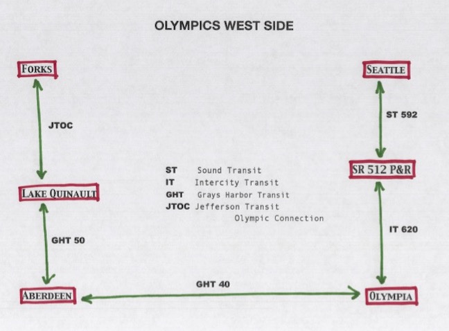
Bus schedules change often so it's useless to post times that will inevitably change. Here are the pertinent bus systems; see links page for current timetables.
This sequence of buses gives access to the west side of ONP, home of the often visited rain forests, as well as the Oil City Road access to the southern end of the coastal beaches. Taking this southern route gets you out here sooner in the afternoon (an advantage, as the access roads leading to the rain forest Park entrances average greater than 15 miles in length). The downside is that you have to leave Seattle earlier in the morning (if indeed that was your starting point). Your options here include, but are not limited to:
- A. Colonel Bob Wilderness (a.k.a. “the Bob”)
- B. Enchanted Valley
- C. North Fork Quinault
- D. Queets River
- E. Hoh River
- F. Bogachiel River
- G. Oil City Road (to ocean beaches)
A - Colonel Bob Wilderness (which lies outside ONP, so you don’t need a reservation)
from bus to trailhead: Leave GHT 50 at the Quinault Merc, as it’s known on the bus schedule. It’s your next to the last stop for ice cream and cold pop (Sadly, I no longer trust the burgers there). Walk 3.5 miles along an easy, flat road to marked trailhead.
from trailhead on onward: It’s a long 7 miles through lovely big trees to the site of an old logging observation lookout. The structure itself is long gone, but the views are panoramic. See the southwest Washington coast laid out as if on a map! There’s year-round water about half a mile from the top of The Bob, with plenty of camping possibilities.
B - The Enchanted Valley
from bus to trailhead: Leaving GHT 50 at the Quinault Merc, you can walk anywhere from 12 to 18 miles to reach the trailhead (generally speaking, the trailhead starts at the point where the road was most recently washed away by wet season rains and flooding—but don’t let that scare you!). It’s paved for about the first dozen miles; thereafter, gravel.
from trailhead onward: It’s largely flat for miles, among huge trees and lovely meadows. Rock walls 3000 feet high to your left and right, with countless waterfalls. Lots of campsites, lots of visitors from all over the world, but you can still find a corner to be all alone. Connections steeply upcountry at its northern end. Lots and lots of massive trees.
C - North Fork Quinault
from bus to trailhead: Again from Quinault Merc, walk 13 miles up that same road to a bridge crossing of the river. Follow signs to trailhead. Total road mileage: 16 miles.
from trailhead onward: Same gorgeous big trees, but with far fewer people. Trail is paralleled by the Skyline Trail, along the ridge steeply to the west. The two routes have connecting trails such that you can easily enjoy both (camp along the river, do a daytime loop up high without all that weight on your back, then head back down to camp). This trail is one end of the famed Press Expedition (look that one up!).
D - Queets River
from bus to trailhead: Tell Jefferson Transit driver you want the Queets Road—the sign is not particularly easy to spot. The road is gravel, and 15 miles long. Vegetation grows right up to the road, so: ear buds out, and pay heed for the sound of cars. There are signs warning against camping along the road, but if daylight demands, just push through the brush over to the river, and camp on a sandbar.
from trailhead onward: At the end of the road sits a lovely campground. To reach the actual trail, you must ford the river. And it’s a wide and vigorous river. Fording it usually cannot be done until late July or August, and water level can rise if it rains upstream while you’re there. Cross the river, whenever possible, with whoever else happens to be there. The best crossing point varies from year to year, and is usually marked. Have I scared you yet?
Once (and if...) you get across, you’ll find a flat trail that extends 15 miles upstream, gaining only 400 feet in the process. And you’ll likely have it all to yourself. Sadly, the trail deadends, and does not connect with any other routes.
Additionally, right at the campground at road’s end stand the state’s largest Black Cottonwood, and the world’s largest Sitka Spruce. And a short distance up the trail on the other side of the river stands the world’s largest Douglas Fir. For all you tree-huggers....
E - Hoh River
from bus to trailhead: Leave Jefferson Transit at the Hoh River Road. The well-paved road is 19 miles long, and flat as a board. On the other hand, the road is extremely well-traveled, and you’re likely to be offered a ride... by strangers with candy. Also, there are 2 separate national forest campgrounds along the road (one at 3 miles, the other at 5), in case you decide to break up that long walk and finish the following day.
from trailhead onward: What can I say about the Hoh rain forest that hasn’t already been said? Big-ass trees, festooned with mosses and lichens. It’s tough to be completely alone there, but you’ll get to ooh-and-aah with visitors from all over the world. Make new friends!
F - Bogachiel River
from bus to trailhead: Leave Jefferson Transit at Undie Road (there’s gotta’ be a story—make one up!). It used to be a largely flat 5 mile road, now it’s about 7 miles. Currently, because of a road washout 5 years ago, there’s a bypass road that heads steeply uphill and then back down. Near the end of the road, it again heads steeply (and gravelly) uphill to the trailhead. If you don’t reach the trailhead before dark, there are lovely campsites along the river (and outside the Park) just before you hit that last uphill.
from trailhead onward: You immediately drop back down toward the river, and into big damn trees! It’s a web of trails for the first mile or two—use your map! But then, once you enter the Park proper, there’s just one trail. It never strays far from the river. There is one large rock outcrop that the trail goes up and over, with some placed rope-assists. Go slowly and carefully on these, particularly if it’s wet.
Oil City Road
from bus to trailhead: Tell driver you want the Oil City Road. It’s 11.5 miles long, mostly paved. But it contains more uphill on its way to the ocean than any such road should possess. And—‘Oil City’? It’s not a city; it’s the site of an attempt at a wildcat oil drilling almost 100 years ago. All that’s left is the name and some rusty bits of metal overgrown with greenery (had a tetanus shot lately?) in the woods off the road.
from trailhead onward: Heading north, you’re on rocky beach for 2 miles, after which you head steeply up into the woods, where you will tromp through interminable mudholes for 5 miles, until you drop down to cross Mosquito Creek.
Here are my thoughts on this: For those 5 miles of mud, you can’t even see the beach. You’re just slogging through all that mud, trying to discern which patches are only a couple inches deep... and which ones will make your boots disappear. For some people, walking the whole length of the ONP beaches is important—I guess it was for me, for a time—but between that 11.5 mile up-and- down-up-and-down road, and all that mud, this section really isn’t worth it. Better to go in at the north end, from Third Beach, make camp somewhere, head south in a day trip as far as Mosquito Creek, and come back out the same way. Or you can do the same silly thing I did every summer for at least fifteen years. Your call.