Chapter 3: Seattle to ONP (East Side):
Updated July 2022
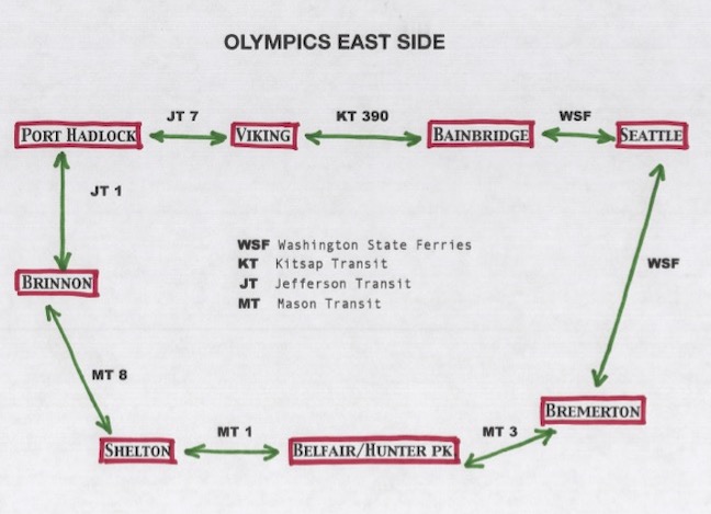
Bus schedules change often so it's useless to post times that will inevitably change. Here are the pertinent bus systems; see links page for current timetables.
These transit sequences give you access to the east flank of ONP—the drainage of the rivers of Big Quilcene, Dosewallips, Duckabush, and the North Fork of the Skokomish. As shown in the graphic, you can approach by either the north or the south. Basically, if your destination is south of the town of Brinnon, you’ll get there earlier in the day if you take the south route; if your destination is Brinnon or north of that, take the north route (by taking the north route, you won’t have to start from Seattle quite so early).
Here’s the catch: The final buses, arriving from north or south, connect at Brinnon at about 3 in the afternoon (or at 6 in the morning, so that’s not reachable either). By bus, you can’t get there any earlier. So, you lose most of a day to get there (one could get all the way to Forks quicker.) For that reason alone, you may want to use this as an out-route only.
That being said, your options here include:
A - Big Quilcene River (you can stay outside the ONP boundary here, so you won’t need a reservation)
from bus to trailhead: Just south of the wide spot in the road that is Quilcene, leave the bus at Fish Hatchery Road (ask driver for help). Head up Penny Creek Road, staying left at 2 junctions. Then go right onto Road #10. Proceed to Notch Pass Trailhead.
from trailhead onward: Notch Pass Trail goes steeply over a ridge, but then drops back down to Lower Big Quilcene Trail (LBQT). This trail is on national forest land, and bicycles and even motorcycles are allowed (I’ve only seen evidence of bicycles...).
The trail is well-maintained, you’re right along the river, and there are plenty of great campsites.
As mentioned, you’ll need a map to negotiate these trails. LBQT #833, available online through the Olympic National Forest, is quite helpful. There is a road... but it’s 18 miles long and has many switchbacks. By using the Notch Pass Trail and the LBQT maps, you’ll cut that distance in half—plus, there are plenty of lovely campsites with a babbling creek a few steps away.
At the upper end of the LBQT, you’ll cross that road you so carefully bypassed and enter the Buckhorn Wilderness; Marmot Pass is only about 5 miles beyond. You’ll stay near the river. Crossing the pass, you could drop down the Dungeness drainage to the north and exit that way. Or you could enter ONP (if you have your reservation!).
B - Dosewallips River
from bus to trailhead: 15 tough miles up the Dosie (as they call it) River Road. Check your map—there are a couple campgrounds along the way if you run out of daylight.
from trailhead onward: Why go up that long road? Because the Dosie leads you quickly into the heart of the Olympic Range; peaks on all sides, views (and trails!) down several major drainages.
C - Duckabush River
from bus to trailhead: Just 7 miles.
from trailhead onward: Long, lonely river trail. You’ll gain elevation to cross the Little Hump, and then the Big Hump. Then you’ll drop back down to the river, where you’ll continue for another 20 miles before heading upcountry. But you’ll have many options from the top to drop back down any of several drainages. Splendid solitude.
D - North Fork Skokomish River
from bus to trailhead: 12.5 miles (Mason Transit has a shuttle that carries you up 3.5 miles up the very steep road to Lake Cushman; see their site for schedule). From there, it’s an up-and-down road along the lake. There are 3 national forest fee campgrounds along the way. You’re aiming for the Staircase trailhead.
from trailhead onward: Stays largely flat for several miles, among huge trees. At the upper end, you find yourself surrounded by rocky peaks above, and river valleys far below. Connects to Dosewallips, North Fork Skokomish, and Quinault rivers.