7. Additional areas
Updated June 2012
See also: Got
Lost?
- Long Beach/Oysterville
- Mt. Baker Wilderness
- Snoqualmie Pass
- Pacific Crest Trail at Columbia River Gorge
Long Beach / Oysterville
This is in response to a request for a route to Long Beach peninsula just north of Astoria, Oregon. It’s an absolutely stupid run: you get to spend more than an hour in Olympia, then another hour and a half in Aberdeen, and then an hour and fifty minutes in South Bend. Total time, Seattle to Oysterville: twelve hours. I could probably ride my bike there in less time.
BUS STUFF:
Seattle to Oysterville (Monday through Friday only)
| Bus | Leaves | at | Arrives | at |
|---|---|---|---|---|
| Sound Transit 590 leaves | Seattle 2nd & University | @ 6:21 / 6:38 AM | Arr. Tacoma Dome Sta | @ 7:11 / 7:28 |
| IT 603 (Oly Express) leaves | Tacoma Dome Sta. | @7:35 | Arr. Olympia Sta. | @ 8:45 |
| GHT 40 | Oly Transit Bay K | @ 10:00 | Arr. Aberdeen Sta. | @ 11:25 |
| Pacific Transit System (PTS) 14 | Aberdeen Sta. |
@ 1:00 PM | Arr. Raymond / 5th & Commercial | @ 1:50 PM |
PTS 32 |
Raymond / 5th & Commercial | @ 1:55 | Arr. South Bend / Pacific & Hwy. 101 | @ 2:15 PM |
| PTS 50 / 24 | South Bend / Pacific & 101 | 4:05 PM | Arr. Ilwaco Port | @ 5:50 PM |
| PTS 20 | Ilwaco Port | 6:00 PM | Arr. Oysterville | @ 6:35 PM |
View Larger Map
Mt. Baker Wilderness
 Seattle
to Concrete (Monday thru Friday)
Seattle
to Concrete (Monday thru Friday)
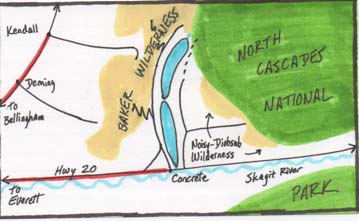
I’ll add this information with a disclaimer right up front: the distances involved (that you’ll have to walk even before you reach any trailhead…) are such that this approach is only for the young, the iron-legged, those with no money but with huge amounts of time to kill, or those with the balls, the stupidity, or enough boundless faith in inherent human kindness to believe they can stick their thumbs out, hope for a lift, and have to not worry one iota about the possibility of being slowly yet skillfully dismembered and then scattered across three or more counties. You can make this trip without hitchhiking, but a lot of hard work is required, and reasonable options are limited. Take a good look at the thumbnail sketch map; note the two red lines -- those represent how close you’ll be able to get on transit.
Public transit will take you east along U.S. Highway 20 (North Cascades
Highway) only as far as the town of Concrete, at the outlet of Lake
Shannon, and south of even the closest entrance to Mount Baker Wilderness
Area by about 20 miles. The only other reasonably close trip would
be east of Lake Shannon, into the primitive, trail-less Noisy-Diobsud
Wilderness. Again, the distance from where you leave the bus in Concrete
to the Wilderness boundary alone is in excess of 20 miles (and you’ll
be wanting to return, too…).
For any other trips, add another ten or fifteen miles of road.
Too bad, from Lake Shannon/Baker Lake you’re midway between Mount Baker to the west, and North Cascades National Park to the east—but both are just a little too far away to easily reach. Sadly, that’s as tantalizingly close as public transit can get you. If you’re into bicycle touring, you may consider this a more reasonable way to access and explore this area.
If I haven’t shaken you off by now…I give up! I tried my best to dissuade you! Here, here’s the information you want! I’m rid of you!
BUS STUFF:
Seattle to Concrete (Monday thru Friday) EARLY RUN
| Bus | Leaves | at | Arrives | at |
|---|---|---|---|---|
| Sound Transit 510 leaves | Seattle 4th & Union | 5:55AM | Arrives Everett Sta. | 6:39AM |
| Skagit Transit 90X | Everett Sta. | 6:50AM | Arrives Skagit Sta. | 7:35AM |
| SkT 208N | Skagit Sta. | 7:45AM | Arrives Cascade Mall | 8:15 AM |
| SkT 300E | Cascade Mall | 8:15AM | Arrives Sedro-Wooley | 8:40AM |
| SkT 717 | Sedro-Wooley | 8:40AM | Arr. Concrete | 9:30AM |
Two limiting factors exist to restrain your timetable:
Skagit Transit 90X is a commuter express bus: it runs until about 8:30 in the morning, but doesn’t resume service until about 4:00 in the afternoon.
Skagit Transit 717 makes just five runs; only the first two or three get you to Concrete with enough daylight for you to get anywhere from there
Seattle to Concrete (M – F) LATER RUN
| Bus | Leaves | at | Arrives | at |
|---|---|---|---|---|
| Sound Transit 510 | Seattle 4th & Union | 7:25AM | Arr. Everett Sta. | 8:09AM |
| SkT 90X | Everett Sta. | 8:25AM | Arr. Skagit Sta. | 9:10AM |
| SkT 208N | Skagit Sta. | 9:15AM | Arr. Cascade Mall | 9:45AM |
| SkT 300E | Cascade Mall | 10:15AM | Arr. Sedro-Wooley | 10:40AM |
| SkT 717 | Sedro-Wooley | 11:40AM | Arr. Concrete | 12:30PM* |
*Once in Concrete, make sure you know—ask your driver—exactly where the bus departs from on the return trip. This may be important later.
Getting Back:
| Bus | Leaves | at | Arrives | at |
|---|---|---|---|---|
| SkT 717 | Concrete | 6:00AM | Arr. Skagit Sta. | *7:15AM |
| SkT 90X | Skagit Sta. | Arr. Everett Sta. | ||
| Sound Transit 510 | Everett Sta. | Arr. See-adl |
Concrete to Seattle (M-F) EARLY RUN
*That 717 reaches the Sedro-Wooley Station at 6:45, then continues on to Skagit Station—to your good fortune. If you choose to get up that early.
This sequence is so freakin’ early that it pretty much necessitates having camped near Concrete the night before (Creekside Campground, a pay-site just west of town at the Grandy Creek turnoff, may be an option), but it is a possibility.
There’s a 10:35AM 717 leaving Concrete, but the aforementioned gap in 90X service means you’d simply have to wait at Skagit Station in Mount Vernon for two and a half hours, and only reach Seattle one hour earlier than if you waited for “the other run.”
Concrete to Seattle (M-F) THE OTHER RUN
| Bus | Leaves | at | Arrives | at |
|---|---|---|---|---|
| SkT 717 | Concrete | 1:35PM | Sedro-Wooley | 2:20PM |
| SkT 300W | Sedro-Wooley | 2:30PM | Cascade Mall | 3:05PM |
| SkT 208S | Cascade Mall | 3:15PM | Skagit Sta. | 3:45PM |
| SkT 90X | Skagit Sta. | 4:15PM | Everett Sta. | 5:00PM |
| Sound. Transit 510 | Everett Sta. | Frequently… | Seattle |
There are two later runs of the 717 leaving Concrete, but from those the necessary connections cannot be made.
FARES: Chump change, really. A couple of bucks.
BICYCLE INFO: All buses listed have bike racks (subject to space available).
View Larger Map
On the subject of Snoqualmie Pass:
One used to be able to flag down a Greyhound bus at the Pass, but, sadly, no longer. So your only option for entering or exiting, say, the Pacific Crest Trail at that point can only be accomplished if you know someone with a car willing to drop you off or pick you up, as the case may be.
(From that point you would be able to head north along the Crest Trail, exiting at Stevens Pass—where Northwestern Trailways does make a flag stop. You could alternatively head south along the Crest Trail, passing first through miles of difficult-to-follow logging roads and clearcuts, returning to civilization in the Packwood area—see following section. These would both be long trips, but they are options.)
Mt. Rainier
I've long declared that Mount Rainier National Park (the Park, henceforth) was unapproachable by transit, local or otherwise. It still pretty much is. The Park sits at the southeast corner of Pierce County, but Pierce Transit doesn't serve that end of the county (it's not really their fault: there just aren't any communities in that area to serve). Seattle/King County Metro Transit will get you to within about thirty miles of the Carbon River entrance at the northwest corner of the Park, which is really too far to be of use to anyone other than perhaps bicyclists.
I even consulted the tour bus company that takes folks up to the Park for quick looks, asking if I could pay the full round-trip fare, but then just get out at the top with my pack, and later find my own way back (I wouldn't be above walking thirty miles downhill). The answer I received was thus: "We don't want dirty smelly hikers with backpacks on our buses." I was actually told this over the phone. I didn't offer than I'd be clean and nice-smelling at the front end of the trip, I just rung off before the conversation got ugly. [Editor's note: She might have been slightly justified.]
I had also rejected the only other approach: from the southeast corner, near the town of Packwood, on the side of Rainier opposite Seattle, as also being too far to be practical. But I just remeasured, and discovered that I had miscalculated:
Stop everything! After posting this in September 2013--that it was possible to reach MRNP by bus--I found out that the Park had closed the Ohanapecosh Visitors Center, the key to this whole thing, for the entire 2013 season. When writing the main body of this section, I didn't think to check with MRNP. I assumed.... Although you can reserve campsites for your itinerary by mail (you cannot to this online for MRNP, as you can for Olympic National Park), you must also check in in person at one of the MRNP Ranger Stations or Visitors Centers listed. Within Ohanapecosh closed, we're simply out of luck. The next closest Ranger Stations are at Paradise, or at White River--and either is just too far to walk from Packwood. So, check back with us in Spring 2014. If the situation for Ohanapecosh changes, we'll let you know. Glance below to see what you might have access to if it does change.
There is one, precisely one, approach via local transit to Mount Rainier National Park. It's a long one, but it's feasible. Follow directions from Seattle to Packwood in Chapter 6. You'll arrive in Packwood at 2:30PM. Grab a bite to eat, water up, and continue north on Highway 12. In about eight miles, angle left onto Highway 123. It's thirteen total miles miles to the Ohanapecosh Visitor Center at the southeast corner of the Park. It's doubtful that you'll get there before closing time, but if you don't, Ohanapecosh Campground is right there. Camp for the night, sign in in the morning. Two trails start right there.
Olallie Creek Trail heads steeply uphill, joining the famed Wonderland Trail in about 3 miles. Eastside Trail parallels the Highway on the opposite side of the Chinook River for about 7 miles before heading upslope. The Grove of the Patriarchs is along the latter trail.
Sadly, that, and other trails radiating out from those two, are about all that's easily accessible. If you head westward at the Stevens Canyon Entrance toward Paradise, the Stevens Canyon Road doglegs mightily, adding another 10 miles or so of road before you reach any trails. I figure, by now, you've had enough of road-walking. Remember: you've still got to return....
Pacific Crest Trail at Columbia River Gorge
In response to a reader write-in, I researched access to the PCT from the Columbia River. Said reader wanted to head north toward Washingtonʼs White Pass. I managed to find transit connections from Vancouver WA (across the Columbia from Portland OR) to the PCT along the Columbia, but personally didnʼt see much use in it, because the PCT in the southernmost section of Washington doesnʼt look all that exciting.
The most interesting feature would be Mount Adams, to which Iʼve long wanted to discover a feasible transit approach route, but even that lies approx. 75 trail miles from the Columbia--much too far for an in-and-back. For anyone other than PCT thrutrippers, this direction offers little reward.
But a few weeks later I took another look and considered turning south at that same point into Oregon instead. Paydirt! The Mark O. Hatfield Wilderness begins just 2 or 3 miles upslope from the south side of the river. You can venture into the Wilderness on any of several trails, in addition to the PCT. Many loop trails could be plotted. River trails, ridge trails, lakes and waterfalls--itʼs all there! And the PCT will lead you to the west flank of Oregonʼs Mount Hood in about thirty (NOT TWENTY) miles, though you can whittle a few miles off that if you avoid the first couple miles of the PCT at the Columbia River and plot a careful course through the Hatfield Wilderness instead.
BUS STUFF:
The bus stuff has its issues. The weak link is, of course, that which is present in the least quantity. In this case, itʼs the Gorge TransLink bus (GTL), which transports you from the east side of Vancouver WA at the Fisherʼs Landing Transit Center to your ultimate destination, the North Bonneville stop just west of the Bonneville Dam.
Monday thru Friday, GTL leaves Fisherʼs Landing at 7:00 AM, and at 6:10 PM. (If youʼre starting from the Portland / Vancouver area, the AM bus might well work for you. If youʼre starting in Seattle, forget it.)
The PM bus gets you to the North Bonneville stop at 7:00 PM, which might be just enough time to grab a spot at the RV Campground you passed on the way into town, or (at the height of summer) to cross the river at the Bonneville Dam and hit one of the other nearby campgrounds (do your homework ahead of time). Convincing your driver to stop right at the Dam Visitors Center would work to your advantage.
As with all small town buses of which there might only be one each day that you can catch--and particularly if youʼve talked your driver into letting you off at someplace other than the legitimate stop--find out, before you leave the bus, PRECISELY WHERE THE STOP HEADING THE OTHER WAY SITS. Few things are more annoying, on a Friday, than watching the only bus ʻtil Monday fly uninterestedly past you, as you stand at what you thought was the stop. ! At any rate, youʼve arrived in North Bonneville: find a place for the night, head south into the Hatfield Wilderness in the morning.
Now ON FRIDAYS ONLY, GTL has a midday run, leaving Fisherʼs Landing at 12:35 PM and reaching North Bonneville at 1:30 PM, making the whole thing a lot easier.
NEWS FLASH!! As of May 2015, Gorge Link Transit debuted WET (West End Transit) buses that shuttle between Fisherʼs Landing and Carson, opening up the area for Summer exploration. Itʼll run between May and the middle of October, but ON SATURDAYS AND SUNDAYS ONLY. So why bother with that early morning/late evening weekday bus nonsense? Arrive, or leave, on the weekend (or connect with another bus at Mount Hood for point-to-point travel. See next section, SEATTLE TO MOUNT HOOD).
RETURN TRIP:
Coming back the other way you run into a similar problem. The PM run gets you into Vancouver too late to make your Amtrak connection. The AM run passes through North Bonneville at 6:03 AM. 6:03 AM.
On your inbound trip, you have already looked assiduously for the absolutely closest legitimate campground to the bus stop (and perhaps even inquired if making a reservation is possible, or advisable). The Lewis & Clark RV & Campground right in North Bonneville looks like a winner. RV campgrounds are often noisy, but itʼs RIGHT THERE! And, in this case, you need that. You should also know exactly how long it takes you to walk from your chosen campground to the bus stop.
Or you could return on a Friday, with that oh-so-civil midday run passing North Bonneville at 11:27 AM.
NOTE: None of these bus sequences work on weekends or major holidays.
Seattle to PCT @ Columbia River (Monday thru Friday)
| Bus | Leaves | at | Arrives | at |
|---|---|---|---|---|
| ST 594 | Eastlake & Stewart | 10:15AM | Tacoma Dome Station | 11:22AM |
| Amtrak 513 | Tacoma Amtrak Sta.* | 12:08 PM | Vancouver Amtrak | 2:25 PM |
| C-Tran 37 | Broadway & 11th** | 4:46 PM | Fisherʼs Landing | 5:37 PM |
| GTL | Fisherʼs Landing | 6:10 PM | North Bonneville | 7:00 PM |
* You could, of course, board Amtrak at King St. Station in Seattle.
It simply adds about
$15 to your fare. Your call.
**After departing Vancouver Amtrak, walk south .7 mile to Broadway & 11th.
Catch CTran
37 eastbound there.
Seattle to PCT @ Columbia River (Friday only midday run)
| Bus | Leaves | at | Arrives | at |
|---|---|---|---|---|
| ST 594 | Eastlake & Stewart | 6:28 AM | Tacoma Dome Station | 7:29 AM |
| Amtrak 513 | Tacoma Amtrak Sta.* | 8:13 AM | Vancouver Amtrak | 10:30 AM |
| C-Tran 37 | Broadway & 11th** | 11:03 AM | Fisherʼs Landing | 11:51 AM |
| GTL | Fisherʼs Landing | 12:35 PM | North Bonneville | 1:27 PM |
* After arriving at Vancouver Amtrak, walk to Broadway & 11th to catch CTran 37.
PCT @ Columbia River to Seattle (Monday thru Friday)
| Bus | Leaves | at | Arrives | at |
|---|---|---|---|---|
| GTL | North Bonneville | 6:03 AM | Fisherʼs Landing | 6:50 AM |
| C-Tran 37 | Fisherʼs Landing | 6:55 AM | Broadway & 11th | 7:45 AM * |
| Amtrak 500 | Vancouver Amtrak | 8:45 AM | Tacoma Amtrak | 11:04 AM |
| ST 590 | Tacoma Dome Station | 11:18 AM | 4th & Pike | 12:09 PM |
* Walk west .7 mile back to Amtrak Station.
PCT @ Columbia River to Seattle (Friday only midday run)
| Bus | Leaves | at | Arrives | at |
|---|---|---|---|---|
| GTL | North Bonneville | 11:27 AM | Fisherʼs Landing | 12:20 PM |
| C-Tran 37 | Fisherʼs Landing | 12:35 PM | Broadway & 11th* | 1:15 PM |
| Amtrak | Vancouver Amtrak | 2:45 PM | Tacoma Amtrak | 5:04 PM |
| ST 590 | Tacoma Dome Station | 5:16 PM | 4th & Pike | 6:05 PM |
* Walk west .7 mile to Amtrak Station.
************************
SEATTLE TO BRIDGE of the GODS (Saturday & Sunday only)
Earlier Run
| Bus | Leaves | at | Arrives | at |
|---|---|---|---|---|
| Amtrak | Seattle King St. Station | 7:30 AM | Vancouver Amtrak | 10:30 AM |
| C-Tran 37 | Evergreen & C Street | 10:35 AM** | Fisherʼs Landing Transit Center | 11:14 AM |
| WET | Fisherʼs Landing | 11:20 AM | Bridge of the Gods | 12:21 PM * |
* Itʼs several blocks from the Amtrak Station to the C-Trans 37 stop at Evergreen & C Street. Hail a cab (cabs always sit just outside train stations at train arrival time). Worst case scenario: you end up having lunch in Vancouver, seeing the sights, and continuing on the later run. See below.
** Sunday times vary slightly. Check and adjust your schedule as necessary. 
Later Run
| Bus | Leaves | at | Arrives | at |
|---|---|---|---|---|
| Amtrak | Seattle King St. Station | 9:35 AM | Vancouver Amtrak | 12:58 PM |
| C-Tran 37 | Evergreen & C Street | 1:35 PM** | Fisherʼs Landing Transit Center | 2:19 PM |
| WET | Fisherʼs Landing | 2:40 PM | Bridge of the Gods | 3:42 PM |
**Sunday times vary slightly. Check and adjust your schedule as necessary.
BRIDGE of the GODS TO SEATTLE (Saturday & Sunday only) Earlier Run 
| Bus | Leaves | at | Arrives | at |
|---|---|---|---|---|
| WET | Bridge of the Gods | 10:00 AM* | Fisherʼs Landing | 11:20 AM |
| C-Tran 37 | Fisherʼs Landing | 11:37** | Evergreen & C Street | 12:15 PM |
| Amtrak | Vancouver | 12:30 PM, 2:55 PM | Seattle King Street Station | 4 hours later |
*Here you have a few options: the posted time is on the eastbound run (and youʼre planning to go west). So you can: pick up the bus at ten and sightsee; you can hike east or west to the nearest westbound stop; or you can call Gorge Link Transit ahead of time and arrange for them to stop for you as they come back westbound about an hour later at the Ice House Lake/PCT sign right across the road from the Bridge of the Gods.
**Times vary slightly on Sunday. Check and adjust your schedule as necessary.
Later Run
| Bus | Leaves | at | Arrives | at |
|---|---|---|---|---|
| WET | Bridge of the Gods | 1:50 PM* | Fisherʼs Landing | 2:40 PM |
| C-Tran 37 | Fisherʼs Landing | 2:57 PM** | Evergreen & C Street | 3:35 PM |
| Amtrak | Vancouver | 4:30, 7:05 PM | Seattle King Street Station | 4 hours later |
*See above Earlier Run notation.
**Times vary slightly on Sunday. Check and adjust your schedule as necessary.
SEATTLE TO MOUNT HOOD (via Portland)
This one comes to us from reader Kurt Hiland. Direct one-day access from Seattle to the Timberland Lodge on the south side of Oregonʼs Mount Hood (and the Pacific Crest Trail is right there). Do a loop of the mountain (about 40 miles). Explore alpine meadows. Or go in a day or two, make camp, and just wander. Always good for the soul. Disembark shy of Timberline and venture into the Salmon-Huckleberry Wilderness. Or...head north along the PCT all the way to the Bridge of the Gods on the Columbia River, cross there and take Skamania Transit back to Vancouver WA, and back to Seattle.*
Another nice thing about this run is that it works seven days a week. The SAM bus runs on a reduced schedule Saturday and Sunday, but there are still several runs each day. The Mount Hood Express (MHE) runs every day except Thanksgiving and Christmas. Folks in the Portland area use these buses in winter to go play in the snow (Hey, take a hint, Washington!).
Getting from Portland Amtrakʼs Union Station onto MAX Light Rail seemed a bit confusing on paper (and even on the Google Map directions) until I looked at the MAX rail system map, and then it all made sense.
If Amtrak is a bit late reaching Portland (as can happen...) all of the buses you need run frequently enough that youʼll still be able to reach Timberline in plenty of time to get on trail and find camp (albeit at 4:30, rather than 2:30). And if that first missed train in Portland does happen, and youʼve done all your “Plan B” calculations, just go find lunch somewhere (the schedule IS a bit tight, otherwise).
Iʼll list the schedule for weekdays. Youʼll have to do the work yourself (or use Google Maps, if you must) for the weekends.
*Directions for this are located just above in the PACIFIC CREST TRAIL VIA COLUMBIA RIVER GORGE section.
SEATTLE to MOUNT HOOD (Monday through Friday)
| Bus | Leaves | at | Arrives | at |
|---|---|---|---|---|
| Amtrak Cascades 501 | Seattle King Street Sta. | 7:30 AM | Portland Union Sta. | 11:20 AM |
| Trimet MAX Green Line | 6th & Hoyt | 11:26 AM | Gateway/99th St. Transit Ctr. | 11:47 AM |
| Trimet MAX Blue Line (eastbound) | Gateway/99th | 11:51 AM | Gresham Transit Ctr. | 12:16 PM |
| Sandy Area Metro (SAM) | Gresham T.C. | 12:26 PM | Sandy Transit Center | 12:55 PM |
| Mt. Hood Express (MHE) | Sandy Transit Center | 1:25 PM | Timberline Lodge | 2:30 PM |
MOUNT HOOD TO SEATTLE (Monday through Friday)
| Bus | Leaves | at | Arrives | at |
|---|---|---|---|---|
| MHE | Timberline Lodge | 10:45 AM | Sandy Transit Center | 11:50 AM |
| SAM | Sandy Transit Center | 12:00 noon | Gresham Transit Center | 12:26 PM |
| Trimet MAX Blue Line | Gresham Transit Center | 12:39 PM | Gateway Station | 1:04 PM |
| Trimet MAX Green Line | Gateway Station | 1:13 PM | Union Station | 1:35 PM |
| Amtrak | Union Station | 2:30, 4:12, 6:50 * | Seattle King Street Station | 4 hours later |
* So, you see, you should be able to leave Timberline later in the day. I leave that to you to plot.
Addresses:
| Gorge Transit Weekend WET Service | www.skamaniacounty.org/weekendtransit | (509) 427-3990 |
| Vancouver Transit | www.c-trans.com/routes | (360) 695-0123 |